|
|
Reset Map | Download PDF |
This ride starts in Bracken, heads out to New Braunfels, then returns. It goes over several short stretches of busy road, but is in general lightly trafficed.
Park on the side of the street on Goll St. on the north side of FM 2252. Please be respectful of the businesses along Goll St. Park on the side of the street on Goll St. on the north side of FM 2252. Please be respectful of the businesses along Goll St. Park on the side of the street on Goll St. on the north side of FM 2252. Please be respectful of the businesses along Goll St.
| Ride Dist. | Type | Description |
|---|---|---|
| 0.1 | conv. store | There is a convenience store on the corner next to the parking area. |
| 17.7 | bar | The River Road Icehouse is at the corner of Hueco Springs Rd. and River Road. |
| 21.1 | bars & tube comp. | There are a couple of tubing companies/bars at the bridge over the Guadalupe River right below Gruene. |
| 21.3 | stores & rest. | There are all kinds of stores and restaurants in Gruene. |
| 22.5 | conv. store | There is a convenience store at the corner of Gruene and Common. |
| 22.7 | conv. store | There is a convenience store at the corner of Gruene and 337. There are also several restaurants on Common between Gruene Rd. and 337. |
| 23.9 | conv. store | There is a convenience store at the corner of Common and Union Ave. |
| 25.6 | conv. store | There is a convenience store at the corner of Wood and Walnut. |
| 37.8 | conv. store | There is a convenience store at the corner of FM 3009 and FM 2252. |
| Ride Dist. | Type | Description |
|---|---|---|
| 0.1 | conv. store | There is a convenience store on the corner next to the parking area. |
| 17.7 | bar | The River Road Icehouse is at the corner of Hueco Springs Rd. and River Road. |
| 19.5 | conv. store | There is a convenience store at the corner of River Rd. and Loop 337. |
| 22.2 | conv. store | There is a convenience store at the corner of Wood and Walnut. |
| 34.4 | conv. store | There is a convenience store at the corner of FM 3009 and FM 2252. |
| Ride Dist. | Type | Description |
|---|---|---|
| 0.1 | conv. store | There is a convenience store on the corner next to the parking area. |
| 22.7 | conv. store | There is a convenience store at the corner of FM 3009 and FM 2252. |
| Help! |
| Total Miles | Instructions | For Miles |
|---|---|---|
| 0.00 | SOUTH on Goll St. | 0.06 |
| 0.06 | RIGHT onto FM 2252 | 0.28 |
| 0.35 | RIGHT onto Marbach Ln. | 2.52 |
| 2.86 | LEFT onto Forrest Waters Circle | 0.53 |
| 3.40 | LEFT onto Water Wood Dr. | 0.06 |
| 3.46 | RIGHT onto Schoenthal Rd. | 0.73 |
| 4.19 | LEFT onto FM 3009 | 0.62 |
| 4.81 | RIGHT onto Schoenthal Rd. | 4.96 |
| 9.77 | RIGHT onto FM 1863 (no sign) | 2.62 |
| 12.38 | LEFT onto Mission Valley Rd. | 1.70 |
| 14.08 | LEFT onto Texas 46 | 0.31 |
| 14.39 | RIGHT onto Hueco Springs Loop Rd. | 4.68 |
| 19.07 | LEFT onto Edwards Blvd. | 1.18 |
| 20.25 | RIGHT onto Ervendberg Ave. | 0.64 |
| 20.90 | LEFT onto Gruene Rd. | 1.59 |
| 22.48 | RIGHT onto Common St. (no sign) | 1.50 |
| 23.99 | STRAIGHT through intersection (no turn) | 0.55 |
| 24.54 | LEFT onto Elizabeth Ave. | 0.22 |
| 24.76 | RIGHT onto Landa Park Dr. | 0.17 |
| 24.93 | LEFT onto Playground Dr. | 0.15 |
| 25.08 | LEFT onto Fredericksburg Rd. | 0.19 |
| 25.27 | RIGHT onto Wood Rd. | 1.16 |
| 26.43 | RIGHT onto Landa St. | 1.59 |
| 28.02 | RIGHT onto Wald Rd. | 2.08 |
| 30.10 | LEFT onto Krueger Canyon | 0.64 |
| 30.74 | RIGHT onto FM 482 | 2.35 |
| 33.09 | RIGHT onto Old Nacogdoches Rd. | 4.68 |
| 37.77 | STRAIGHT through intersection (no turn) | 0.35 |
| 38.12 | LEFT onto Nacogdoches Loop (no sign; first left) | 0.82 |
| 38.94 | LEFT onto FM 2252 (no sign) | 0.86 |
| 39.80 | RIGHT onto Goll St. | 0.05 |
| 39.85 | Arrive at finish |
| Total Miles | Instructions | For Miles |
|---|---|---|
| 0.00 |
SOUTH on Goll St. Go towards FM 2252. Goll St. Dead-end street with businesses along it. lanes: 2 shoulder: 0 traffic: Light speed: |
0.06 |
| 0.06 |
RIGHT onto FM 2252 FM 2252 Be careful because there is no shoulder along this road and there is heavy traffic. Luckily the turn comes quickly. lanes: 2 shoulder: 1/4 traffic: Heavy speed: |
0.28 |
| 0.35 |
RIGHT onto Marbach Ln. Marbach Ln. is the first street on the right. Marbach Lane/Bindseil Lane Marbach Lane becomes Bindseil Lane at the sharp bend. Interestingly, there is a street sign where the names change. Bindseil Lane crosses over Bat Cave Rd. into the Forrest Waters sub-division. lanes: 2 shoulder: 0 traffic: Light speed: |
2.52 |
| 2.86 |
LEFT onto Forrest Waters Circle After crossing over Bat Cave Rd., Bindseil Lane dead-ends into Forrest Waters Circle. The street sign here is rock column with the street name on the side. Forrest Waters Circle Forrest Waters Circle winds through nice houses. You will frequently see deer in the yards. lanes: 2 shoulder: 0 traffic: Light to none speed: |
0.53 |
| 3.40 |
LEFT onto Water Wood Dr. The street sign here is rock column with the street name on the side. Keep an eye out for it. Water Wood Dr. Water Wood Dr. is really short almost immediately dead-ends into Schoenthal Rd. lanes: 2 shoulder: 0 traffic: None speed: |
0.06 |
| 3.46 |
RIGHT onto Schoenthal Rd. Water Wood Dr. dead-ends into Schoenthal Rd. Schoenthal Rd. Houses line this road. lanes: 2 shoulder: 0 traffic: Light speed: |
0.73 |
| 4.19 |
LEFT onto FM 3009 Watch out for cross-traffic because FM 3009 is busy. FM 3009 This is a busy road, but it has a good shoulder and it's a short stretch. lanes: 2 shoulder: 2 traffic: Moderate to heavy speed: |
0.62 |
| 4.81 |
RIGHT onto Schoenthal Rd. The turn is at the bottom of the hill. Schoenthal Rd. This is a longish stretch of road that passes a few sub-divisions before going through ranches. lanes: 2 shoulder: 0 traffic: Light speed: |
4.96 |
| 9.77 |
RIGHT onto FM 1863 (no sign) Schoenthal Rd. dead-ends into FM 1863. FM 1863 This is the hairiest stretch of road on this ride. It has fast but light traffic and a minimal shoulder. lanes: 2 shoulder: 1/2 traffic: Light speed: |
2.62 |
| 12.38 |
LEFT onto Mission Valley Rd. A wide shoulder opens up on FM 1863 shortly before the turn. Mission Valley Rd. This road passes by Newcombe Tennis Ranch lanes: 2 shoulder: 0 traffic: Light speed: |
1.70 |
| 14.08 |
LEFT onto Texas 46 Mission Valley Rd. dead-ends into Texas 46. Texas 46 The traffic is heavy on this road, but there's a small shoulder and you only stay on it for a short hop. lanes: 4 shoulder: 1/2 traffic: Moderate speed: |
0.31 |
| 14.39 |
RIGHT onto Hueco Springs Loop Rd. There is usually a lot of gravel in this corner. Hueco Springs Loop Rd./River Rd. Hueco Springs Loop Rd. becomes River Rd. at the ice-house. lanes: 2 shoulder: 0 traffic: Moderate speed: |
4.68 |
| 19.07 |
LEFT onto Edwards Blvd. There's a church on the corner. It's the only building around. Edwards Blvd. Passes through a country neighborhood. lanes: 2 shoulder: 0 traffic: Light to none speed: |
1.18 |
| 20.25 |
RIGHT onto Ervendberg Ave. Ervendberg Ave. This road goes under a narrow, timber railroad trestle. lanes: 1 shoulder: 0 traffic: Light to none speed: |
0.64 |
| 20.90 |
LEFT onto Gruene Rd. Ervendberg Ave. dead-ends into Gruene Rd. Gruene Rd. Gruene Rd. climbs the hill into Gruene, then passes on through it. There's lots of new construction along this road. lanes: 2 shoulder: 0 traffic: Light speed: |
1.59 |
| 22.48 |
RIGHT onto Common St. (no sign) This is an intersection with a light. There's a convenience store on the corner. Common St. You pass near to Schlitterbahn at the end. lanes: 2 shoulder: 0 traffic: Light speed: |
1.50 |
| 23.99 |
STRAIGHT through intersection (no turn) Common St. turns into Hinman Island Dr. Hinman Island Dr. The Comal river is on your left. This is a good spot to dip your feet in the water if you're so inclined. lanes: 2 shoulder: 0 traffic: Light speed: |
0.55 |
| 24.54 |
LEFT onto Elizabeth Ave. Hinman Island Dr. dead-ends into Elizabeth Ave. right after crossing the train tracks. Elizabeth Ave. Wurstfest is on your left. lanes: 2 shoulder: 0 traffic: Light speed: |
0.22 |
| 24.76 |
RIGHT onto Landa Park Dr. Elizabeth Ave. dead-ends into Land Park Dr. Landa Park Dr. Your now passing through Landa Park. lanes: 2 shoulder: 0 traffic: Light speed: |
0.17 |
| 24.93 |
LEFT onto Playground Dr. The turn is just after crossing the bridge and the railroad tracks. Playground Dr. You're still in Landa Park. There are picnic areas and playgrounds all around. lanes: 1 shoulder: 0 traffic: Light speed: |
0.15 |
| 25.08 |
LEFT onto Fredericksburg Rd. The turn is just after crossing the railroad tracks. Fredericksburg Rd. There is a power station on your left and baseball fields on your right. lanes: 2 shoulder: 1/2 traffic: Light speed: |
0.19 |
| 25.27 |
RIGHT onto Wood Rd. Wood Rd. Pass through neigborhoods, crossing one busy street. lanes: 2 shoulder: 0 traffic: Light speed: |
1.16 |
| 26.43 |
RIGHT onto Landa St. Wood Rd. dead-ends into Landa St. Landa St./Wald Rd. Landa St. becomes Wald Rd. when it crosses the railroad tracks. lanes: 2 shoulder: 0 traffic: Light speed: |
1.59 |
| 28.02 |
RIGHT onto Wald Rd. Wald Rd. Pass by a large cement plant on the right. lanes: 2 shoulder: 0 traffic: Light speed: |
2.08 |
| 30.10 |
LEFT onto Krueger Canyon Krueger Canyon There are buffalo on the right just before crossing the railroad tracks. lanes: 2 shoulder: 0 traffic: Light speed: |
0.64 |
| 30.74 |
RIGHT onto FM 482 Krueger Canyon dead-ends into FM 482. FM 482 Pass through Comal, TX, though there's nothing marking it. lanes: 2 shoulder: 0 traffic: Light speed: |
2.35 |
| 33.09 |
RIGHT onto Old Nacogdoches Rd. Old Nacogdoches Rd. Pass by farms and another cement plant. lanes: 2 shoulder: 0 traffic: Light to moderate speed: |
4.68 |
| 37.77 |
STRAIGHT through intersection (no turn) Old Nacogdoches Rd. becomes FM 2252 when it crosses FM 3009. FM 2252 This is a short, busy stretch with a good shoulder. lanes: 2 shoulder: 2 traffic: Heavy speed: |
0.35 |
| 38.12 |
LEFT onto Nacogdoches Loop (no sign; first left) Be careful crossing traffic here since FM 2252 is busy. Nacogdoches Loop This nice little road gets you off the busy FM2252 for a little bit. lanes: 2 shoulder: 0 traffic: Light speed: |
0.82 |
| 38.94 |
LEFT onto FM 2252 (no sign) Nacogdoches Loop dead-ends back into FM 2252. The turn is at the top of the hill. FM 2252 You are almost done! lanes: 2 shoulder: 1/4 traffic: Heavy speed: |
0.86 |
| 39.80 |
RIGHT onto Goll St. The only street sign is actually on the left side of FM 2252. Goll St. You parked somewhere near here. lanes: 2 shoulder: 0 traffic: Light speed: |
0.05 |
| 39.85 | Arrive at finish |
| Total Miles | Instructions | For Miles |
|---|---|---|
| 0.00 | SOUTH on Goll St. | 0.06 |
| 0.06 | RIGHT onto FM 2252 | 0.28 |
| 0.35 | RIGHT onto Marbach Ln. | 2.52 |
| 2.86 | LEFT onto Forrest Waters Circle | 0.53 |
| 3.40 | LEFT onto Water Wood Dr. | 0.06 |
| 3.46 | RIGHT onto Schoenthal Rd. | 0.73 |
| 4.19 | LEFT onto FM 3009 | 0.62 |
| 4.81 | RIGHT onto Schoenthal Rd. | 4.96 |
| 9.77 | RIGHT onto FM 1863 (no sign) | 2.62 |
| 12.38 | LEFT onto Mission Valley Rd. | 1.70 |
| 14.08 | LEFT onto Texas 46 | 0.31 |
| 14.39 | RIGHT onto Hueco Springs Loop Rd. | 5.11 |
| 19.49 | STRAIGHT through intersection (no turn) | 1.21 |
| 20.70 | LEFT onto Elizabeth Ave. | 0.67 |
| 21.37 | RIGHT onto Landa Park Dr. | 0.17 |
| 21.54 | LEFT onto Playground Dr. | 0.15 |
| 21.69 | LEFT onto Fredericksburg Rd. | 0.19 |
| 21.88 | RIGHT onto Wood Rd. | 1.16 |
| 23.04 | RIGHT onto Landa St. | 1.59 |
| 24.63 | RIGHT onto Wald Rd. | 2.08 |
| 26.72 | LEFT onto Krueger Canyon | 0.64 |
| 27.35 | RIGHT onto FM 482 | 2.35 |
| 29.71 | RIGHT onto Old Nacogdoches Rd. | 4.68 |
| 34.38 | STRAIGHT through intersection (no turn) | 0.35 |
| 34.74 | LEFT onto Nacogdoches Loop (no sign; first left) | 0.82 |
| 35.56 | LEFT onto FM 2252 (no sign) | 0.86 |
| 36.42 | RIGHT onto Goll St. | 0.05 |
| 36.46 | Arrive at finish |
| Total Miles | Instructions | For Miles |
|---|---|---|
| 0.00 |
SOUTH on Goll St. Go towards FM 2252. Goll St. Dead-end street with businesses along it. lanes: 2 shoulder: 0 traffic: Light speed: |
0.06 |
| 0.06 |
RIGHT onto FM 2252 FM 2252 Be careful because there is no shoulder along this road and there is heavy traffic. Luckily the turn comes quickly. lanes: 2 shoulder: 1/4 traffic: Heavy speed: |
0.28 |
| 0.35 |
RIGHT onto Marbach Ln. Marbach Ln. is the first street on the right. Marbach Lane/Bindseil Lane Marbach Lane becomes Bindseil Lane at the sharp bend. Interestingly, there is a street sign where the names change. Bindseil Lane crosses over Bat Cave Rd. into the Forrest Waters sub-division. lanes: 2 shoulder: 0 traffic: Light speed: |
2.52 |
| 2.86 |
LEFT onto Forrest Waters Circle After crossing over Bat Cave Rd., Bindseil Lane dead-ends into Forrest Waters Circle. The street sign here is rock column with the street name on the side. Forrest Waters Circle Forrest Waters Circle winds through nice houses. You will frequently see deer in the yards. lanes: 2 shoulder: 0 traffic: Light to none speed: |
0.53 |
| 3.40 |
LEFT onto Water Wood Dr. The street sign here is rock column with the street name on the side. Keep an eye out for it. Water Wood Dr. Water Wood Dr. is really short almost immediately dead-ends into Schoenthal Rd. lanes: 2 shoulder: 0 traffic: None speed: |
0.06 |
| 3.46 |
RIGHT onto Schoenthal Rd. Water Wood Dr. dead-ends into Schoenthal Rd. Schoenthal Rd. Houses line this road. lanes: 2 shoulder: 0 traffic: Light speed: |
0.73 |
| 4.19 |
LEFT onto FM 3009 Watch out for cross-traffic because FM 3009 is busy. FM 3009 This is a busy road, but it has a good shoulder and it's a short stretch. lanes: 2 shoulder: 2 traffic: Moderate to heavy speed: |
0.62 |
| 4.81 |
RIGHT onto Schoenthal Rd. The turn is at the bottom of the hill. Schoenthal Rd. This is a longish stretch of road that passes a few sub-divisions before going through ranches. lanes: 2 shoulder: 0 traffic: Light speed: |
4.96 |
| 9.77 |
RIGHT onto FM 1863 (no sign) Schoenthal Rd. dead-ends into FM 1863. FM 1863 This is the hairiest stretch of road on this ride. It has fast but light traffic and a minimal shoulder. lanes: 2 shoulder: 1/2 traffic: Light speed: |
2.62 |
| 12.38 |
LEFT onto Mission Valley Rd. A wide shoulder opens up on FM 1863 shortly before the turn. Mission Valley Rd. This road passes by Newcombe Tennis Ranch lanes: 2 shoulder: 0 traffic: Light speed: |
1.70 |
| 14.08 |
LEFT onto Texas 46 Mission Valley Rd. dead-ends into Texas 46. Texas 46 The traffic is heavy on this road, but there's a small shoulder and you only stay on it for a short hop. lanes: 4 shoulder: 1/2 traffic: Moderate speed: |
0.31 |
| 14.39 |
RIGHT onto Hueco Springs Loop Rd. There is usually a lot of gravel in this corner. Hueco Springs Loop Rd./River Rd. Hueco Springs Loop Rd. becomes River Rd. at the ice-house. lanes: 2 shoulder: 0 traffic: Moderate speed: |
5.11 |
| 19.49 |
STRAIGHT through intersection (no turn) River Rd. becomes much less busy when it crosses Loop 337. River Rd./Klingemann St. This street goes through a quiet neighborhood. lanes: 2 shoulder: 0 traffic: Light speed: |
1.21 |
| 20.70 |
LEFT onto Elizabeth Ave. Kligemann St. dead-ends into Elizabeth Ave. at the golf course. Elizabeth Ave. lanes: 2 shoulder: 0 traffic: Light speed: |
0.67 |
| 21.37 |
RIGHT onto Landa Park Dr. Elizabeth Ave. dead-ends into Land Park Dr. Landa Park Dr. Your now passing through Landa Park. lanes: 2 shoulder: 0 traffic: Light speed: |
0.17 |
| 21.54 |
LEFT onto Playground Dr. The turn is just after crossing the bridge and the railroad tracks. Playground Dr. You're still in Landa Park. There are picnic areas and playgrounds all around. lanes: 1 shoulder: 0 traffic: Light speed: |
0.15 |
| 21.69 |
LEFT onto Fredericksburg Rd. The turn is just after crossing the railroad tracks. Fredericksburg Rd. There is a power station on your left and baseball fields on your right. lanes: 2 shoulder: 1/2 traffic: Light speed: |
0.19 |
| 21.88 |
RIGHT onto Wood Rd. Wood Rd. Pass through neigborhoods, crossing one busy street. lanes: 2 shoulder: 0 traffic: Light speed: |
1.16 |
| 23.04 |
RIGHT onto Landa St. Wood Rd. dead-ends into Landa St. Landa St./Wald Rd. Landa St. becomes Wald Rd. when it crosses the railroad tracks. lanes: 2 shoulder: 0 traffic: Light speed: |
1.59 |
| 24.63 |
RIGHT onto Wald Rd. Wald Rd. Pass by a large cement plant on the right. lanes: 2 shoulder: 0 traffic: Light speed: |
2.08 |
| 26.72 |
LEFT onto Krueger Canyon Krueger Canyon There are buffalo on the right just before crossing the railroad tracks. lanes: 2 shoulder: 0 traffic: Light speed: |
0.64 |
| 27.35 |
RIGHT onto FM 482 Krueger Canyon dead-ends into FM 482. FM 482 Pass through Comal, TX, though there's nothing marking it. lanes: 2 shoulder: 0 traffic: Light speed: |
2.35 |
| 29.71 |
RIGHT onto Old Nacogdoches Rd. Old Nacogdoches Rd. Pass by farms and another cement plant. lanes: 2 shoulder: 0 traffic: Light to moderate speed: |
4.68 |
| 34.38 |
STRAIGHT through intersection (no turn) Old Nacogdoches Rd. becomes FM 2252 when it crosses FM 3009. FM 2252 This is a short, busy stretch with a good shoulder. lanes: 2 shoulder: 2 traffic: Heavy speed: |
0.35 |
| 34.74 |
LEFT onto Nacogdoches Loop (no sign; first left) Be careful crossing traffic here since FM 2252 is busy. Nacogdoches Loop This nice little road gets you off the busy FM2252 for a little bit. lanes: 2 shoulder: 0 traffic: Light speed: |
0.82 |
| 35.56 |
LEFT onto FM 2252 (no sign) Nacogdoches Loop dead-ends back into FM 2252. The turn is at the top of the hill. FM 2252 You are almost done! lanes: 2 shoulder: 1/4 traffic: Heavy speed: |
0.86 |
| 36.42 |
RIGHT onto Goll St. The only street sign is actually on the left side of FM 2252. Goll St. You parked somewhere near here. lanes: 2 shoulder: 0 traffic: Light speed: |
0.05 |
| 36.46 | Arrive at finish |
| Total Miles | Instructions | For Miles |
|---|---|---|
| 0.00 | SOUTH on Goll St. | 0.06 |
| 0.06 | RIGHT onto FM 2252 | 0.28 |
| 0.35 | RIGHT onto Marbach Ln. | 2.52 |
| 2.86 | LEFT onto Forrest Waters Circle | 0.53 |
| 3.40 | LEFT onto Water Wood Dr. | 0.06 |
| 3.46 | RIGHT onto Schoenthal Rd. | 0.73 |
| 4.19 | LEFT onto FM 3009 | 0.62 |
| 4.81 | RIGHT onto Schoenthal Rd. | 4.95 |
| 9.75 | RIGHT onto FM 1863 (no sign) | 1.66 |
| 11.41 | RIGHT onto Krueger Canyon | 3.62 |
| 15.03 | RIGHT onto Krueger Canyon | 0.64 |
| 15.67 | RIGHT onto FM 482 | 2.35 |
| 18.02 | RIGHT onto Old Nacogdoches Rd. | 4.68 |
| 22.70 | STRAIGHT through intersection (no turn) | 0.35 |
| 23.05 | LEFT onto Nacogdoches Loop (no sign; first left) | 0.82 |
| 23.87 | LEFT onto FM 2252 (no sign) | 0.86 |
| 24.73 | RIGHT onto Goll St. | 0.05 |
| 24.77 | Arrive at finish |
| Total Miles | Instructions | For Miles |
|---|---|---|
| 0.00 |
SOUTH on Goll St. Go towards FM 2252. Goll St. Dead-end street with businesses along it. lanes: 2 shoulder: 0 traffic: Light speed: |
0.06 |
| 0.06 |
RIGHT onto FM 2252 FM 2252 Be careful because there is no shoulder along this road and there is heavy traffic. Luckily the turn comes quickly. lanes: 2 shoulder: 1/4 traffic: Heavy speed: |
0.28 |
| 0.35 |
RIGHT onto Marbach Ln. Marbach Ln. is the first street on the right. Marbach Lane/Bindseil Lane Marbach Lane becomes Bindseil Lane at the sharp bend. Interestingly, there is a street sign where the names change. Bindseil Lane crosses over Bat Cave Rd. into the Forrest Waters sub-division. lanes: 2 shoulder: 0 traffic: Light speed: |
2.52 |
| 2.86 |
LEFT onto Forrest Waters Circle After crossing over Bat Cave Rd., Bindseil Lane dead-ends into Forrest Waters Circle. The street sign here is rock column with the street name on the side. Forrest Waters Circle Forrest Waters Circle winds through nice houses. You will frequently see deer in the yards. lanes: 2 shoulder: 0 traffic: Light to none speed: |
0.53 |
| 3.40 |
LEFT onto Water Wood Dr. The street sign here is rock column with the street name on the side. Keep an eye out for it. Water Wood Dr. Water Wood Dr. is really short almost immediately dead-ends into Schoenthal Rd. lanes: 2 shoulder: 0 traffic: None speed: |
0.06 |
| 3.46 |
RIGHT onto Schoenthal Rd. Water Wood Dr. dead-ends into Schoenthal Rd. Schoenthal Rd. Houses line this road. lanes: 2 shoulder: 0 traffic: Light speed: |
0.73 |
| 4.19 |
LEFT onto FM 3009 Watch out for cross-traffic because FM 3009 is busy. FM 3009 This is a busy road, but it has a good shoulder and it's a short stretch. lanes: 2 shoulder: 2 traffic: Moderate to heavy speed: |
0.62 |
| 4.81 |
RIGHT onto Schoenthal Rd. The turn is at the bottom of the hill. Schoenthal Rd. This is a longish stretch of road that passes a few sub-divisions before going through ranches. lanes: 2 shoulder: 0 traffic: Light speed: |
4.95 |
| 9.75 |
RIGHT onto FM 1863 (no sign) Schoenthal Rd. dead-ends into FM 1863. FM 1863 This is the hairiest stretch of road on this ride. It has fast but light traffic and a minimal shoulder. lanes: 2 shoulder: 1/2 traffic: Light speed: |
1.66 |
| 11.41 |
RIGHT onto Krueger Canyon Krueger Canyon This road is generally downhill, with one short rise and some false flats. lanes: 2 shoulder: 0 traffic: Light speed: |
3.62 |
| 15.03 |
RIGHT onto Krueger Canyon The turn is shortly after you come down the steep hill and pass under the railroad bridge. Krueger Canyon There are buffalo on the right just before crossing the railroad tracks. lanes: 2 shoulder: 0 traffic: Light speed: |
0.64 |
| 15.67 |
RIGHT onto FM 482 Krueger Canyon dead-ends into FM 482. FM 482 Pass through Comal, TX, though there's nothing marking it. lanes: 2 shoulder: 0 traffic: Light speed: |
2.35 |
| 18.02 |
RIGHT onto Old Nacogdoches Rd. Old Nacogdoches Rd. Pass by farms and another cement plant. lanes: 2 shoulder: 0 traffic: Light to moderate speed: |
4.68 |
| 22.70 |
STRAIGHT through intersection (no turn) Old Nacogdoches Rd. becomes FM 2252 when it crosses FM 3009. FM 2252 This is a short, busy stretch with a good shoulder. lanes: 2 shoulder: 2 traffic: Heavy speed: |
0.35 |
| 23.05 |
LEFT onto Nacogdoches Loop (no sign; first left) Be careful crossing traffic here since FM 2252 is busy. Nacogdoches Loop This nice little road gets you off the busy FM2252 for a little bit. lanes: 2 shoulder: 0 traffic: Light speed: |
0.82 |
| 23.87 |
LEFT onto FM 2252 (no sign) Nacogdoches Loop dead-ends back into FM 2252. The turn is at the top of the hill. FM 2252 You are almost done! lanes: 2 shoulder: 1/4 traffic: Heavy speed: |
0.86 |
| 24.73 |
RIGHT onto Goll St. The only street sign is actually on the left side of FM 2252. Goll St. You parked somewhere near here. lanes: 2 shoulder: 0 traffic: Light speed: |
0.05 |
| 24.77 | Arrive at finish |
| Ride Analysis | |||
|---|---|---|---|
| elevation change (feet) | distance (miles) | avg. grade (%) | |
| Climbing | 1932.02 | 17.04 | 2.1 |
| Descending | -1935.47 | 22.81 | -1.6 |
| Overall | 3867.49 | 39.85 | |
| Top 10 Climbs: | ||
|---|---|---|
| Rank | Gradient (%) | Distance (miles) |
| 1 | 3.3 | 0.49 |
| 2 | 2.2 | 0.51 |
| 3 | 2.1 | 0.79 |
| 4 | 2.0 | 0.46 |
| 5 | 1.3 | 0.89 |
| 6 | 1.2 | 0.53 |
| 7 | 1.0 | 0.52 |
| 8 | 0.6 | 0.57 |
| 9 | 0.5 | 0.57 |
| 10 | 0.4 | 0.47 |
| Segment Analysis | |||
|---|---|---|---|
| elevation change (feet) | distance (miles) | avg. grade (%) | |
| Climbing | 13.16 | 0.04 | 6.7 |
| Descending | -11.15 | 0.02 | -8.5 |
| Overall | 24.32 | 0.06 | |
| Segment Analysis | |||
|---|---|---|---|
| elevation change (feet) | distance (miles) | avg. grade (%) | |
| Climbing | 4.59 | 0.05 | 1.7 |
| Descending | -3.00 | 0.23 | -0.2 |
| Overall | 7.60 | 0.28 | |
| Top 10 Climbs: | ||
|---|---|---|
| Rank | Gradient (%) | Distance (miles) |
| 1 | 0.3 | 0.09 |
| Segment Analysis | |||
|---|---|---|---|
| elevation change (feet) | distance (miles) | avg. grade (%) | |
| Climbing | 192.18 | 1.37 | 2.7 |
| Descending | -77.76 | 1.15 | -1.3 |
| Overall | 269.94 | 2.52 | |
| Top 10 Climbs: | ||
|---|---|---|
| Rank | Gradient (%) | Distance (miles) |
| 1 | 4.1 | 0.14 |
| 2 | 2.3 | 0.37 |
| 3 | 2.0 | 0.27 |
| 4 | 1.9 | 0.16 |
| 5 | 1.0 | 0.06 |
| 6 | 0.9 | 0.07 |
| 7 | 0.7 | 0.13 |
| 8 | 0.6 | 0.05 |
| 9 | 0.6 | 0.26 |
| 10 | 0.2 | 0.16 |
| Segment Analysis | |||
|---|---|---|---|
| elevation change (feet) | distance (miles) | avg. grade (%) | |
| Climbing | 51.85 | 0.26 | 3.8 |
| Descending | -31.50 | 0.28 | -2.2 |
| Overall | 83.35 | 0.53 | |
| Top 10 Climbs: | ||
|---|---|---|
| Rank | Gradient (%) | Distance (miles) |
| 1 | 4.2 | 0.07 |
| 2 | 1.8 | 0.11 |
| 3 | 1.7 | 0.06 |
| 4 | 1.2 | 0.10 |
| Segment Analysis | |||
|---|---|---|---|
| elevation change (feet) | distance (miles) | avg. grade (%) | |
| Climbing | 12.80 | 0.04 | 5.5 |
| Descending | -2.27 | 0.02 | -2.4 |
| Overall | 15.07 | 0.06 | |
| Top 10 Climbs: | ||
|---|---|---|
| Rank | Gradient (%) | Distance (miles) |
| 1 | 4.6 | 0.05 |
| Segment Analysis | |||
|---|---|---|---|
| elevation change (feet) | distance (miles) | avg. grade (%) | |
| Climbing | 47.24 | 0.34 | 2.7 |
| Descending | -56.56 | 0.40 | -2.7 |
| Overall | 103.81 | 0.73 | |
| Top 10 Climbs: | ||
|---|---|---|
| Rank | Gradient (%) | Distance (miles) |
| 1 | 2.0 | 0.39 |
| Segment Analysis | |||
|---|---|---|---|
| elevation change (feet) | distance (miles) | avg. grade (%) | |
| Climbing | 0.00 | 0.00 | 0.0 |
| Descending | -73.42 | 0.62 | -2.3 |
| Overall | 73.42 | 0.62 | |
| Segment Analysis | |||
|---|---|---|---|
| elevation change (feet) | distance (miles) | avg. grade (%) | |
| Climbing | 279.89 | 2.43 | 2.2 |
| Descending | -254.27 | 2.53 | -1.9 |
| Overall | 534.15 | 4.96 | |
| Top 10 Climbs: | ||
|---|---|---|
| Rank | Gradient (%) | Distance (miles) |
| 1 | 2.1 | 0.79 |
| 2 | 1.7 | 0.39 |
| 3 | 1.5 | 0.37 |
| 4 | 1.3 | 0.89 |
| 5 | 1.2 | 0.15 |
| 6 | 0.0 | 0.13 |
| Segment Analysis | |||
|---|---|---|---|
| elevation change (feet) | distance (miles) | avg. grade (%) | |
| Climbing | 103.59 | 1.15 | 1.7 |
| Descending | -84.65 | 1.46 | -1.1 |
| Overall | 188.24 | 2.62 | |
| Top 10 Climbs: | ||
|---|---|---|
| Rank | Gradient (%) | Distance (miles) |
| 1 | 2.1 | 0.29 |
| 2 | 1.5 | 0.28 |
| 3 | 1.2 | 0.53 |
| 4 | 0.6 | 0.05 |
| 5 | 0.3 | 0.21 |
| Segment Analysis | |||
|---|---|---|---|
| elevation change (feet) | distance (miles) | avg. grade (%) | |
| Climbing | 44.22 | 0.40 | 2.1 |
| Descending | -96.13 | 1.30 | -1.4 |
| Overall | 140.35 | 1.70 | |
| Top 10 Climbs: | ||
|---|---|---|
| Rank | Gradient (%) | Distance (miles) |
| 1 | 1.6 | 0.39 |
| 2 | 0.9 | 0.03 |

| Segment Analysis | |||
|---|---|---|---|
| elevation change (feet) | distance (miles) | avg. grade (%) | |
| Climbing | 48.96 | 0.30 | 3.1 |
| Descending | 0.00 | 0.01 | 0.0 |
| Overall | 48.96 | 0.31 | |
| Segment Analysis | |||
|---|---|---|---|
| elevation change (feet) | distance (miles) | avg. grade (%) | |
| Climbing | 237.53 | 1.60 | 2.8 |
| Descending | -437.52 | 3.08 | -2.7 |
| Overall | 675.05 | 4.68 | |
| Top 10 Climbs: | ||
|---|---|---|
| Rank | Gradient (%) | Distance (miles) |
| 1 | 4.5 | 0.09 |
| 2 | 3.3 | 0.49 |
| 3 | 1.5 | 0.11 |
| 4 | 1.5 | 0.26 |
| 5 | 1.4 | 0.19 |
| 6 | 1.4 | 0.20 |
| 7 | 1.3 | 0.05 |
| 8 | 0.6 | 0.10 |
| 9 | 0.6 | 0.15 |
| 10 | 0.4 | 0.06 |
| Segment Analysis | |||
|---|---|---|---|
| elevation change (feet) | distance (miles) | avg. grade (%) | |
| Climbing | 66.97 | 0.38 | 3.3 |
| Descending | -99.74 | 0.80 | -2.4 |
| Overall | 166.71 | 1.18 | |
| Top 10 Climbs: | ||
|---|---|---|
| Rank | Gradient (%) | Distance (miles) |
| 1 | 6.4 | 0.06 |
| 2 | 2.8 | 0.18 |
| 3 | 2.0 | 0.16 |
| Segment Analysis | |||
|---|---|---|---|
| elevation change (feet) | distance (miles) | avg. grade (%) | |
| Climbing | 15.75 | 0.15 | 2.0 |
| Descending | -49.00 | 0.49 | -1.9 |
| Overall | 64.74 | 0.64 | |
| Top 10 Climbs: | ||
|---|---|---|
| Rank | Gradient (%) | Distance (miles) |
| 1 | 1.3 | 0.10 |
| 2 | 0.7 | 0.13 |
| Segment Analysis | |||
|---|---|---|---|
| elevation change (feet) | distance (miles) | avg. grade (%) | |
| Climbing | 102.08 | 0.68 | 2.8 |
| Descending | -60.37 | 0.91 | -1.3 |
| Overall | 162.45 | 1.59 | |
| Top 10 Climbs: | ||
|---|---|---|
| Rank | Gradient (%) | Distance (miles) |
| 1 | 4.1 | 0.32 |
| 2 | 1.9 | 0.02 |
| 3 | 0.5 | 0.06 |
| 4 | 0.5 | 0.23 |
| Segment Analysis | |||
|---|---|---|---|
| elevation change (feet) | distance (miles) | avg. grade (%) | |
| Climbing | 60.04 | 0.54 | 2.1 |
| Descending | -90.50 | 0.97 | -1.8 |
| Overall | 150.54 | 1.50 | |
| Top 10 Climbs: | ||
|---|---|---|
| Rank | Gradient (%) | Distance (miles) |
| 1 | 2.0 | 0.46 |
| 2 | 1.5 | 0.02 |
| 3 | 0.8 | 0.15 |
| Segment Analysis | |||
|---|---|---|---|
| elevation change (feet) | distance (miles) | avg. grade (%) | |
| Climbing | 19.03 | 0.30 | 1.2 |
| Descending | -30.57 | 0.25 | -2.3 |
| Overall | 49.60 | 0.55 | |
| Top 10 Climbs: | ||
|---|---|---|
| Rank | Gradient (%) | Distance (miles) |
| 1 | 1.6 | 0.04 |
| 2 | 0.5 | 0.05 |
| Segment Analysis | |||
|---|---|---|---|
| elevation change (feet) | distance (miles) | avg. grade (%) | |
| Climbing | 9.61 | 0.17 | 1.1 |
| Descending | -5.91 | 0.05 | -2.2 |
| Overall | 15.51 | 0.22 | |
| Top 10 Climbs: | ||
|---|---|---|
| Rank | Gradient (%) | Distance (miles) |
| 1 | 0.5 | 0.18 |
| Segment Analysis | |||
|---|---|---|---|
| elevation change (feet) | distance (miles) | avg. grade (%) | |
| Climbing | 8.09 | 0.07 | 2.3 |
| Descending | -1.64 | 0.11 | -0.3 |
| Overall | 9.73 | 0.17 | |
| Top 10 Climbs: | ||
|---|---|---|
| Rank | Gradient (%) | Distance (miles) |
| 1 | 0.9 | 0.07 |
| Segment Analysis | |||
|---|---|---|---|
| elevation change (feet) | distance (miles) | avg. grade (%) | |
| Climbing | 5.22 | 0.06 | 1.5 |
| Descending | -6.56 | 0.08 | -1.5 |
| Overall | 11.78 | 0.15 | |
| Top 10 Climbs: | ||
|---|---|---|
| Rank | Gradient (%) | Distance (miles) |
| 1 | 1.0 | 0.03 |
| 2 | 0.8 | 0.08 |
| Segment Analysis | |||
|---|---|---|---|
| elevation change (feet) | distance (miles) | avg. grade (%) | |
| Climbing | 8.61 | 0.12 | 1.3 |
| Descending | -3.28 | 0.07 | -0.9 |
| Overall | 11.89 | 0.19 | |
| Top 10 Climbs: | ||
|---|---|---|
| Rank | Gradient (%) | Distance (miles) |
| 1 | 0.6 | 0.17 |
| Segment Analysis | |||
|---|---|---|---|
| elevation change (feet) | distance (miles) | avg. grade (%) | |
| Climbing | 61.68 | 0.60 | 1.9 |
| Descending | -50.22 | 0.55 | -1.7 |
| Overall | 111.90 | 1.16 | |
| Top 10 Climbs: | ||
|---|---|---|
| Rank | Gradient (%) | Distance (miles) |
| 1 | 2.0 | 0.13 |
| 2 | 1.6 | 0.28 |
| 3 | 0.7 | 0.26 |
| 4 | 0.6 | 0.04 |
| Segment Analysis | |||
|---|---|---|---|
| elevation change (feet) | distance (miles) | avg. grade (%) | |
| Climbing | 36.75 | 0.49 | 1.4 |
| Descending | -41.17 | 1.10 | -0.7 |
| Overall | 77.91 | 1.59 | |
| Top 10 Climbs: | ||
|---|---|---|
| Rank | Gradient (%) | Distance (miles) |
| 1 | 1.1 | 0.14 |
| 2 | 1.0 | 0.05 |
| 3 | 0.9 | 0.03 |
| 4 | 0.7 | 0.24 |
| 5 | 0.6 | 0.15 |
| Segment Analysis | |||
|---|---|---|---|
| elevation change (feet) | distance (miles) | avg. grade (%) | |
| Climbing | 57.41 | 0.81 | 1.3 |
| Descending | -42.10 | 1.27 | -0.6 |
| Overall | 99.51 | 2.08 | |
| Top 10 Climbs: | ||
|---|---|---|
| Rank | Gradient (%) | Distance (miles) |
| 1 | 1.4 | 0.27 |
| 2 | 0.7 | 0.08 |
| 3 | 0.7 | 0.08 |
| 4 | 0.7 | 0.14 |
| 5 | 0.5 | 0.57 |
| 6 | 0.4 | 0.18 |
| Segment Analysis | |||
|---|---|---|---|
| elevation change (feet) | distance (miles) | avg. grade (%) | |
| Climbing | 21.24 | 0.23 | 1.8 |
| Descending | -12.80 | 0.41 | -0.6 |
| Overall | 34.04 | 0.64 | |
| Top 10 Climbs: | ||
|---|---|---|
| Rank | Gradient (%) | Distance (miles) |
| 1 | 1.5 | 0.12 |
| 2 | 0.7 | 0.20 |
| Segment Analysis | |||
|---|---|---|---|
| elevation change (feet) | distance (miles) | avg. grade (%) | |
| Climbing | 85.63 | 1.33 | 1.2 |
| Descending | -67.32 | 1.03 | -1.2 |
| Overall | 152.95 | 2.35 | |
| Top 10 Climbs: | ||
|---|---|---|
| Rank | Gradient (%) | Distance (miles) |
| 1 | 1.0 | 0.38 |
| 2 | 0.8 | 0.08 |
| 3 | 0.8 | 0.19 |
| 4 | 0.4 | 0.15 |
| 5 | 0.4 | 0.47 |
| 6 | 0.3 | 0.18 |
| Segment Analysis | |||
|---|---|---|---|
| elevation change (feet) | distance (miles) | avg. grade (%) | |
| Climbing | 265.07 | 2.58 | 1.9 |
| Descending | -116.14 | 2.09 | -1.0 |
| Overall | 381.21 | 4.68 | |
| Top 10 Climbs: | ||
|---|---|---|
| Rank | Gradient (%) | Distance (miles) |
| 1 | 2.5 | 0.45 |
| 2 | 2.2 | 0.51 |
| 3 | 1.6 | 0.40 |
| 4 | 1.1 | 0.20 |
| 5 | 1.0 | 0.52 |
| 6 | 0.9 | 0.26 |
| 7 | 0.8 | 0.08 |
| 8 | 0.7 | 0.05 |
| 9 | 0.6 | 0.57 |
| Segment Analysis | |||
|---|---|---|---|
| elevation change (feet) | distance (miles) | avg. grade (%) | |
| Climbing | 8.20 | 0.05 | 3.1 |
| Descending | -12.89 | 0.30 | -0.8 |
| Overall | 21.09 | 0.35 | |
| Top 10 Climbs: | ||
|---|---|---|
| Rank | Gradient (%) | Distance (miles) |
| 1 | 0.6 | 0.11 |
| Segment Analysis | |||
|---|---|---|---|
| elevation change (feet) | distance (miles) | avg. grade (%) | |
| Climbing | 36.42 | 0.26 | 2.6 |
| Descending | -36.15 | 0.56 | -1.2 |
| Overall | 72.57 | 0.82 | |
| Top 10 Climbs: | ||
|---|---|---|
| Rank | Gradient (%) | Distance (miles) |
| 1 | 2.5 | 0.24 |
| 2 | 0.2 | 0.16 |
| Segment Analysis | |||
|---|---|---|---|
| elevation change (feet) | distance (miles) | avg. grade (%) | |
| Climbing | 28.22 | 0.23 | 2.3 |
| Descending | -70.08 | 0.63 | -2.1 |
| Overall | 98.30 | 0.86 | |
| Top 10 Climbs: | ||
|---|---|---|
| Rank | Gradient (%) | Distance (miles) |
| 1 | 1.5 | 0.26 |
| Segment Analysis | |||
|---|---|---|---|
| elevation change (feet) | distance (miles) | avg. grade (%) | |
| Climbing | 0.00 | 0.00 | 0.0 |
| Descending | -10.83 | 0.05 | -4.6 |
| Overall | 10.83 | 0.05 | |
| Ride Analysis | |||
|---|---|---|---|
| elevation change (feet) | distance (miles) | avg. grade (%) | |
| Climbing | 1677.43 | 15.45 | 2.1 |
| Descending | -1683.67 | 21.01 | -1.5 |
| Overall | 3361.10 | 36.46 | |
| Top 10 Climbs: | ||
|---|---|---|
| Rank | Gradient (%) | Distance (miles) |
| 1 | 2.8 | 0.50 |
| 2 | 2.5 | 0.45 |
| 3 | 2.2 | 0.51 |
| 4 | 2.1 | 0.79 |
| 5 | 1.3 | 0.89 |
| 6 | 1.2 | 0.53 |
| 7 | 1.0 | 0.52 |
| 8 | 0.6 | 0.57 |
| 9 | 0.5 | 0.57 |
| 10 | 0.4 | 0.47 |
| Segment Analysis | |||
|---|---|---|---|
| elevation change (feet) | distance (miles) | avg. grade (%) | |
| Climbing | 13.16 | 0.04 | 6.7 |
| Descending | -11.15 | 0.02 | -8.5 |
| Overall | 24.32 | 0.06 | |
| Segment Analysis | |||
|---|---|---|---|
| elevation change (feet) | distance (miles) | avg. grade (%) | |
| Climbing | 4.59 | 0.05 | 1.7 |
| Descending | -3.00 | 0.23 | -0.2 |
| Overall | 7.60 | 0.28 | |
| Top 10 Climbs: | ||
|---|---|---|
| Rank | Gradient (%) | Distance (miles) |
| 1 | 0.3 | 0.09 |
| Segment Analysis | |||
|---|---|---|---|
| elevation change (feet) | distance (miles) | avg. grade (%) | |
| Climbing | 192.18 | 1.37 | 2.7 |
| Descending | -77.76 | 1.15 | -1.3 |
| Overall | 269.94 | 2.52 | |
| Top 10 Climbs: | ||
|---|---|---|
| Rank | Gradient (%) | Distance (miles) |
| 1 | 4.1 | 0.14 |
| 2 | 2.3 | 0.37 |
| 3 | 2.0 | 0.27 |
| 4 | 1.9 | 0.16 |
| 5 | 1.0 | 0.06 |
| 6 | 0.9 | 0.07 |
| 7 | 0.7 | 0.13 |
| 8 | 0.6 | 0.05 |
| 9 | 0.6 | 0.26 |
| 10 | 0.2 | 0.16 |
| Segment Analysis | |||
|---|---|---|---|
| elevation change (feet) | distance (miles) | avg. grade (%) | |
| Climbing | 51.85 | 0.26 | 3.8 |
| Descending | -31.50 | 0.28 | -2.2 |
| Overall | 83.35 | 0.53 | |
| Top 10 Climbs: | ||
|---|---|---|
| Rank | Gradient (%) | Distance (miles) |
| 1 | 4.2 | 0.07 |
| 2 | 1.8 | 0.11 |
| 3 | 1.7 | 0.06 |
| 4 | 1.2 | 0.10 |
| Segment Analysis | |||
|---|---|---|---|
| elevation change (feet) | distance (miles) | avg. grade (%) | |
| Climbing | 12.80 | 0.04 | 5.5 |
| Descending | -2.27 | 0.02 | -2.4 |
| Overall | 15.07 | 0.06 | |
| Top 10 Climbs: | ||
|---|---|---|
| Rank | Gradient (%) | Distance (miles) |
| 1 | 4.6 | 0.05 |
| Segment Analysis | |||
|---|---|---|---|
| elevation change (feet) | distance (miles) | avg. grade (%) | |
| Climbing | 47.24 | 0.34 | 2.7 |
| Descending | -56.56 | 0.40 | -2.7 |
| Overall | 103.81 | 0.73 | |
| Top 10 Climbs: | ||
|---|---|---|
| Rank | Gradient (%) | Distance (miles) |
| 1 | 2.0 | 0.39 |
| Segment Analysis | |||
|---|---|---|---|
| elevation change (feet) | distance (miles) | avg. grade (%) | |
| Climbing | 0.00 | 0.00 | 0.0 |
| Descending | -73.42 | 0.62 | -2.3 |
| Overall | 73.42 | 0.62 | |
| Segment Analysis | |||
|---|---|---|---|
| elevation change (feet) | distance (miles) | avg. grade (%) | |
| Climbing | 279.89 | 2.43 | 2.2 |
| Descending | -254.27 | 2.53 | -1.9 |
| Overall | 534.15 | 4.96 | |
| Top 10 Climbs: | ||
|---|---|---|
| Rank | Gradient (%) | Distance (miles) |
| 1 | 2.1 | 0.79 |
| 2 | 1.7 | 0.39 |
| 3 | 1.5 | 0.37 |
| 4 | 1.3 | 0.89 |
| 5 | 1.2 | 0.15 |
| 6 | 0.0 | 0.13 |
| Segment Analysis | |||
|---|---|---|---|
| elevation change (feet) | distance (miles) | avg. grade (%) | |
| Climbing | 103.59 | 1.15 | 1.7 |
| Descending | -84.65 | 1.46 | -1.1 |
| Overall | 188.24 | 2.62 | |
| Top 10 Climbs: | ||
|---|---|---|
| Rank | Gradient (%) | Distance (miles) |
| 1 | 2.1 | 0.29 |
| 2 | 1.5 | 0.28 |
| 3 | 1.2 | 0.53 |
| 4 | 0.6 | 0.05 |
| 5 | 0.3 | 0.21 |
| Segment Analysis | |||
|---|---|---|---|
| elevation change (feet) | distance (miles) | avg. grade (%) | |
| Climbing | 44.22 | 0.40 | 2.1 |
| Descending | -96.13 | 1.30 | -1.4 |
| Overall | 140.35 | 1.70 | |
| Top 10 Climbs: | ||
|---|---|---|
| Rank | Gradient (%) | Distance (miles) |
| 1 | 1.6 | 0.39 |
| 2 | 0.9 | 0.03 |
| Segment Analysis | |||
|---|---|---|---|
| elevation change (feet) | distance (miles) | avg. grade (%) | |
| Climbing | 48.96 | 0.30 | 3.1 |
| Descending | 0.00 | 0.01 | 0.0 |
| Overall | 48.96 | 0.31 | |
| Segment Analysis | |||
|---|---|---|---|
| elevation change (feet) | distance (miles) | avg. grade (%) | |
| Climbing | 206.04 | 1.68 | 2.3 |
| Descending | -422.38 | 3.43 | -2.3 |
| Overall | 628.42 | 5.11 | |
| Top 10 Climbs: | ||
|---|---|---|
| Rank | Gradient (%) | Distance (miles) |
| 1 | 2.8 | 0.50 |
| 2 | 2.6 | 0.09 |
| 3 | 1.7 | 0.19 |
| 4 | 1.2 | 0.17 |
| 5 | 1.2 | 0.18 |
| 6 | 1.0 | 0.24 |
| 7 | 0.9 | 0.07 |
| 8 | 0.6 | 0.31 |
| 9 | 0.3 | 0.10 |
| 10 | 0.3 | 0.11 |
| Segment Analysis | |||
|---|---|---|---|
| elevation change (feet) | distance (miles) | avg. grade (%) | |
| Climbing | 28.35 | 0.34 | 1.6 |
| Descending | -75.46 | 0.87 | -1.6 |
| Overall | 103.81 | 1.21 | |
| Top 10 Climbs: | ||
|---|---|---|
| Rank | Gradient (%) | Distance (miles) |
| 1 | 1.5 | 0.08 |
| 2 | 1.5 | 0.04 |
| 3 | 0.6 | 0.15 |
| 4 | 0.0 | 0.13 |

| Segment Analysis | |||
|---|---|---|---|
| elevation change (feet) | distance (miles) | avg. grade (%) | |
| Climbing | 22.02 | 0.22 | 1.9 |
| Descending | -23.95 | 0.45 | -1.0 |
| Overall | 45.97 | 0.67 | |
| Top 10 Climbs: | ||
|---|---|---|
| Rank | Gradient (%) | Distance (miles) |
| 1 | 2.5 | 0.09 |
| 2 | 0.9 | 0.11 |
| 3 | 0.3 | 0.09 |
| Segment Analysis | |||
|---|---|---|---|
| elevation change (feet) | distance (miles) | avg. grade (%) | |
| Climbing | 8.09 | 0.07 | 2.3 |
| Descending | -1.64 | 0.11 | -0.3 |
| Overall | 9.73 | 0.17 | |
| Top 10 Climbs: | ||
|---|---|---|
| Rank | Gradient (%) | Distance (miles) |
| 1 | 0.9 | 0.07 |
| Segment Analysis | |||
|---|---|---|---|
| elevation change (feet) | distance (miles) | avg. grade (%) | |
| Climbing | 5.22 | 0.06 | 1.5 |
| Descending | -6.56 | 0.08 | -1.5 |
| Overall | 11.78 | 0.15 | |
| Top 10 Climbs: | ||
|---|---|---|
| Rank | Gradient (%) | Distance (miles) |
| 1 | 1.0 | 0.03 |
| 2 | 0.8 | 0.08 |
| Segment Analysis | |||
|---|---|---|---|
| elevation change (feet) | distance (miles) | avg. grade (%) | |
| Climbing | 8.61 | 0.12 | 1.3 |
| Descending | -3.28 | 0.07 | -0.9 |
| Overall | 11.89 | 0.19 | |
| Top 10 Climbs: | ||
|---|---|---|
| Rank | Gradient (%) | Distance (miles) |
| 1 | 0.6 | 0.17 |
| Segment Analysis | |||
|---|---|---|---|
| elevation change (feet) | distance (miles) | avg. grade (%) | |
| Climbing | 61.68 | 0.60 | 1.9 |
| Descending | -50.22 | 0.55 | -1.7 |
| Overall | 111.90 | 1.16 | |
| Top 10 Climbs: | ||
|---|---|---|
| Rank | Gradient (%) | Distance (miles) |
| 1 | 2.0 | 0.13 |
| 2 | 1.6 | 0.28 |
| 3 | 0.7 | 0.26 |
| 4 | 0.6 | 0.04 |
| Segment Analysis | |||
|---|---|---|---|
| elevation change (feet) | distance (miles) | avg. grade (%) | |
| Climbing | 36.75 | 0.49 | 1.4 |
| Descending | -41.17 | 1.10 | -0.7 |
| Overall | 77.91 | 1.59 | |
| Top 10 Climbs: | ||
|---|---|---|
| Rank | Gradient (%) | Distance (miles) |
| 1 | 1.1 | 0.14 |
| 2 | 1.0 | 0.05 |
| 3 | 0.9 | 0.03 |
| 4 | 0.7 | 0.24 |
| 5 | 0.6 | 0.15 |
| Segment Analysis | |||
|---|---|---|---|
| elevation change (feet) | distance (miles) | avg. grade (%) | |
| Climbing | 57.41 | 0.81 | 1.3 |
| Descending | -42.10 | 1.27 | -0.6 |
| Overall | 99.51 | 2.08 | |
| Top 10 Climbs: | ||
|---|---|---|
| Rank | Gradient (%) | Distance (miles) |
| 1 | 1.4 | 0.27 |
| 2 | 0.7 | 0.08 |
| 3 | 0.7 | 0.08 |
| 4 | 0.7 | 0.14 |
| 5 | 0.5 | 0.57 |
| 6 | 0.4 | 0.18 |
| Segment Analysis | |||
|---|---|---|---|
| elevation change (feet) | distance (miles) | avg. grade (%) | |
| Climbing | 21.24 | 0.23 | 1.8 |
| Descending | -12.80 | 0.41 | -0.6 |
| Overall | 34.04 | 0.64 | |
| Top 10 Climbs: | ||
|---|---|---|
| Rank | Gradient (%) | Distance (miles) |
| 1 | 1.5 | 0.12 |
| 2 | 0.7 | 0.20 |
| Segment Analysis | |||
|---|---|---|---|
| elevation change (feet) | distance (miles) | avg. grade (%) | |
| Climbing | 85.63 | 1.33 | 1.2 |
| Descending | -67.32 | 1.03 | -1.2 |
| Overall | 152.95 | 2.35 | |
| Top 10 Climbs: | ||
|---|---|---|
| Rank | Gradient (%) | Distance (miles) |
| 1 | 1.0 | 0.38 |
| 2 | 0.8 | 0.08 |
| 3 | 0.8 | 0.19 |
| 4 | 0.4 | 0.15 |
| 5 | 0.4 | 0.47 |
| 6 | 0.3 | 0.18 |
| Segment Analysis | |||
|---|---|---|---|
| elevation change (feet) | distance (miles) | avg. grade (%) | |
| Climbing | 265.07 | 2.58 | 1.9 |
| Descending | -116.14 | 2.09 | -1.0 |
| Overall | 381.21 | 4.68 | |
| Top 10 Climbs: | ||
|---|---|---|
| Rank | Gradient (%) | Distance (miles) |
| 1 | 2.5 | 0.45 |
| 2 | 2.2 | 0.51 |
| 3 | 1.6 | 0.40 |
| 4 | 1.1 | 0.20 |
| 5 | 1.0 | 0.52 |
| 6 | 0.9 | 0.26 |
| 7 | 0.8 | 0.08 |
| 8 | 0.7 | 0.05 |
| 9 | 0.6 | 0.57 |
| Segment Analysis | |||
|---|---|---|---|
| elevation change (feet) | distance (miles) | avg. grade (%) | |
| Climbing | 8.20 | 0.05 | 3.1 |
| Descending | -12.89 | 0.30 | -0.8 |
| Overall | 21.09 | 0.35 | |
| Top 10 Climbs: | ||
|---|---|---|
| Rank | Gradient (%) | Distance (miles) |
| 1 | 0.6 | 0.11 |
| Segment Analysis | |||
|---|---|---|---|
| elevation change (feet) | distance (miles) | avg. grade (%) | |
| Climbing | 36.42 | 0.26 | 2.6 |
| Descending | -36.15 | 0.56 | -1.2 |
| Overall | 72.57 | 0.82 | |
| Top 10 Climbs: | ||
|---|---|---|
| Rank | Gradient (%) | Distance (miles) |
| 1 | 2.5 | 0.24 |
| 2 | 0.2 | 0.16 |
| Segment Analysis | |||
|---|---|---|---|
| elevation change (feet) | distance (miles) | avg. grade (%) | |
| Climbing | 28.22 | 0.23 | 2.3 |
| Descending | -70.08 | 0.63 | -2.1 |
| Overall | 98.30 | 0.86 | |
| Top 10 Climbs: | ||
|---|---|---|
| Rank | Gradient (%) | Distance (miles) |
| 1 | 1.5 | 0.26 |
| Segment Analysis | |||
|---|---|---|---|
| elevation change (feet) | distance (miles) | avg. grade (%) | |
| Climbing | 0.00 | 0.00 | 0.0 |
| Descending | -10.83 | 0.05 | -4.6 |
| Overall | 10.83 | 0.05 | |
| Ride Analysis | |||
|---|---|---|---|
| elevation change (feet) | distance (miles) | avg. grade (%) | |
| Climbing | 1229.57 | 10.92 | 2.1 |
| Descending | -1250.80 | 13.85 | -1.7 |
| Overall | 2480.37 | 24.77 | |
| Top 10 Climbs: | ||
|---|---|---|
| Rank | Gradient (%) | Distance (miles) |
| 1 | 2.5 | 0.45 |
| 2 | 2.2 | 0.51 |
| 3 | 2.1 | 0.79 |
| 4 | 1.8 | 0.45 |
| 5 | 1.7 | 0.39 |
| 6 | 1.6 | 0.40 |
| 7 | 1.3 | 0.89 |
| 8 | 1.0 | 0.52 |
| 9 | 0.6 | 0.57 |
| 10 | 0.4 | 0.47 |
| Segment Analysis | |||
|---|---|---|---|
| elevation change (feet) | distance (miles) | avg. grade (%) | |
| Climbing | 13.16 | 0.04 | 6.7 |
| Descending | -11.15 | 0.02 | -8.5 |
| Overall | 24.32 | 0.06 | |
| Segment Analysis | |||
|---|---|---|---|
| elevation change (feet) | distance (miles) | avg. grade (%) | |
| Climbing | 4.59 | 0.05 | 1.7 |
| Descending | -3.00 | 0.23 | -0.2 |
| Overall | 7.60 | 0.28 | |
| Top 10 Climbs: | ||
|---|---|---|
| Rank | Gradient (%) | Distance (miles) |
| 1 | 0.3 | 0.09 |
| Segment Analysis | |||
|---|---|---|---|
| elevation change (feet) | distance (miles) | avg. grade (%) | |
| Climbing | 192.18 | 1.37 | 2.7 |
| Descending | -77.76 | 1.15 | -1.3 |
| Overall | 269.94 | 2.52 | |
| Top 10 Climbs: | ||
|---|---|---|
| Rank | Gradient (%) | Distance (miles) |
| 1 | 4.1 | 0.14 |
| 2 | 2.3 | 0.37 |
| 3 | 2.0 | 0.27 |
| 4 | 1.9 | 0.16 |
| 5 | 1.0 | 0.06 |
| 6 | 0.9 | 0.07 |
| 7 | 0.7 | 0.13 |
| 8 | 0.6 | 0.05 |
| 9 | 0.6 | 0.26 |
| 10 | 0.2 | 0.16 |

| Segment Analysis | |||
|---|---|---|---|
| elevation change (feet) | distance (miles) | avg. grade (%) | |
| Climbing | 51.85 | 0.26 | 3.8 |
| Descending | -31.50 | 0.28 | -2.2 |
| Overall | 83.35 | 0.53 | |
| Top 10 Climbs: | ||
|---|---|---|
| Rank | Gradient (%) | Distance (miles) |
| 1 | 4.2 | 0.07 |
| 2 | 1.8 | 0.11 |
| 3 | 1.7 | 0.06 |
| 4 | 1.2 | 0.10 |
| Segment Analysis | |||
|---|---|---|---|
| elevation change (feet) | distance (miles) | avg. grade (%) | |
| Climbing | 12.80 | 0.04 | 5.5 |
| Descending | -2.27 | 0.02 | -2.4 |
| Overall | 15.07 | 0.06 | |
| Top 10 Climbs: | ||
|---|---|---|
| Rank | Gradient (%) | Distance (miles) |
| 1 | 4.6 | 0.05 |
| Segment Analysis | |||
|---|---|---|---|
| elevation change (feet) | distance (miles) | avg. grade (%) | |
| Climbing | 47.24 | 0.34 | 2.7 |
| Descending | -56.56 | 0.40 | -2.7 |
| Overall | 103.81 | 0.73 | |
| Top 10 Climbs: | ||
|---|---|---|
| Rank | Gradient (%) | Distance (miles) |
| 1 | 2.0 | 0.39 |
| Segment Analysis | |||
|---|---|---|---|
| elevation change (feet) | distance (miles) | avg. grade (%) | |
| Climbing | 0.00 | 0.00 | 0.0 |
| Descending | -73.42 | 0.62 | -2.3 |
| Overall | 73.42 | 0.62 | |
| Segment Analysis | |||
|---|---|---|---|
| elevation change (feet) | distance (miles) | avg. grade (%) | |
| Climbing | 279.59 | 2.42 | 2.2 |
| Descending | -254.27 | 2.53 | -1.9 |
| Overall | 533.86 | 4.95 | |
| Top 10 Climbs: | ||
|---|---|---|
| Rank | Gradient (%) | Distance (miles) |
| 1 | 2.1 | 0.79 |
| 2 | 1.7 | 0.39 |
| 3 | 1.5 | 0.37 |
| 4 | 1.3 | 0.89 |
| 5 | 1.2 | 0.15 |
| 6 | 0.0 | 0.13 |
| Segment Analysis | |||
|---|---|---|---|
| elevation change (feet) | distance (miles) | avg. grade (%) | |
| Climbing | 81.99 | 0.67 | 2.3 |
| Descending | -56.43 | 0.99 | -1.1 |
| Overall | 138.42 | 1.66 | |
| Top 10 Climbs: | ||
|---|---|---|
| Rank | Gradient (%) | Distance (miles) |
| 1 | 2.1 | 0.27 |
| 2 | 0.8 | 0.11 |
| 3 | 0.8 | 0.04 |
| 4 | 0.3 | 0.10 |
| Segment Analysis | |||
|---|---|---|---|
| elevation change (feet) | distance (miles) | avg. grade (%) | |
| Climbing | 101.38 | 1.06 | 1.8 |
| Descending | -358.23 | 2.56 | -2.7 |
| Overall | 459.61 | 3.62 | |
| Top 10 Climbs: | ||
|---|---|---|
| Rank | Gradient (%) | Distance (miles) |
| 1 | 1.8 | 0.45 |
| 2 | 0.4 | 0.12 |
| 3 | 0.4 | 0.22 |
| 4 | 0.4 | 0.24 |
| 5 | 0.2 | 0.24 |
| Segment Analysis | |||
|---|---|---|---|
| elevation change (feet) | distance (miles) | avg. grade (%) | |
| Climbing | 21.24 | 0.23 | 1.8 |
| Descending | -12.80 | 0.41 | -0.6 |
| Overall | 34.04 | 0.64 | |
| Top 10 Climbs: | ||
|---|---|---|
| Rank | Gradient (%) | Distance (miles) |
| 1 | 1.5 | 0.12 |
| 2 | 0.7 | 0.20 |
| Segment Analysis | |||
|---|---|---|---|
| elevation change (feet) | distance (miles) | avg. grade (%) | |
| Climbing | 85.63 | 1.33 | 1.2 |
| Descending | -67.32 | 1.03 | -1.2 |
| Overall | 152.95 | 2.35 | |
| Top 10 Climbs: | ||
|---|---|---|
| Rank | Gradient (%) | Distance (miles) |
| 1 | 1.0 | 0.38 |
| 2 | 0.8 | 0.08 |
| 3 | 0.8 | 0.19 |
| 4 | 0.4 | 0.15 |
| 5 | 0.4 | 0.47 |
| 6 | 0.3 | 0.18 |
| Segment Analysis | |||
|---|---|---|---|
| elevation change (feet) | distance (miles) | avg. grade (%) | |
| Climbing | 265.07 | 2.58 | 1.9 |
| Descending | -116.14 | 2.09 | -1.0 |
| Overall | 381.21 | 4.68 | |
| Top 10 Climbs: | ||
|---|---|---|
| Rank | Gradient (%) | Distance (miles) |
| 1 | 2.5 | 0.45 |
| 2 | 2.2 | 0.51 |
| 3 | 1.6 | 0.40 |
| 4 | 1.1 | 0.20 |
| 5 | 1.0 | 0.52 |
| 6 | 0.9 | 0.26 |
| 7 | 0.8 | 0.08 |
| 8 | 0.7 | 0.05 |
| 9 | 0.6 | 0.57 |
| Segment Analysis | |||
|---|---|---|---|
| elevation change (feet) | distance (miles) | avg. grade (%) | |
| Climbing | 8.20 | 0.05 | 3.1 |
| Descending | -12.89 | 0.30 | -0.8 |
| Overall | 21.09 | 0.35 | |
| Top 10 Climbs: | ||
|---|---|---|
| Rank | Gradient (%) | Distance (miles) |
| 1 | 0.6 | 0.11 |
| Segment Analysis | |||
|---|---|---|---|
| elevation change (feet) | distance (miles) | avg. grade (%) | |
| Climbing | 36.42 | 0.26 | 2.6 |
| Descending | -36.15 | 0.56 | -1.2 |
| Overall | 72.57 | 0.82 | |
| Top 10 Climbs: | ||
|---|---|---|
| Rank | Gradient (%) | Distance (miles) |
| 1 | 2.5 | 0.24 |
| 2 | 0.2 | 0.16 |
| Segment Analysis | |||
|---|---|---|---|
| elevation change (feet) | distance (miles) | avg. grade (%) | |
| Climbing | 28.22 | 0.23 | 2.3 |
| Descending | -70.08 | 0.63 | -2.1 |
| Overall | 98.30 | 0.86 | |
| Top 10 Climbs: | ||
|---|---|---|
| Rank | Gradient (%) | Distance (miles) |
| 1 | 1.5 | 0.26 |
| Segment Analysis | |||
|---|---|---|---|
| elevation change (feet) | distance (miles) | avg. grade (%) | |
| Climbing | 0.00 | 0.00 | 0.0 |
| Descending | -10.83 | 0.05 | -4.6 |
| Overall | 10.83 | 0.05 | |


The first thing you have to do for any of these rides is get to the starting place. This tab gives you everything you need to get there.
Up top is a description of the starting place. Below that is a box to enter the address of where you're coming from so you can get directions. When you've entered the address, press the 'Get directions to parking' button and it'll tell you how to get there. You'll get the usual Google Maps turn-by-turn instructions below the address box, and you'll get a corresponding line drawn on the map. Follow these directions, and you'll get to the ride.
Once you've digested the directions you will probably get tired of having the map cluttered up by them. Just hit the 'Clear parking directions from map' button and they will go away.
If you'd like to print out the driving directions, the "Get printable parking directions" button will bring up a Google Maps page with the parking directions in them that you can manipulate and print out.
Here's all the information you need to know about stops on the ride. Mostly this is where to get water and food and how far away it is. I generally prefer to list convenience stores and things like that because they're geared to deal with travelers on the go. I don't include all the restaurants and hotels and everything else, since those things aren't really necessary to help you get through the ride and there are far better resources on the web for finding those sorts of things. If there's a restaurant I particularly like eating at after a ride, I'll mention it in the overview.
You can click on any stop in the list and it'll show its info window on the map. This helpful if you're not sure where on the map a stop is.
Ride Dist.: Distance to the stop from the start of the ride. This is in miles. Sometimes I include stops that aren't actually on the route but are close to it. For those, I'll show how far off the route the stop is. These are as-the-crow-flies distances based on the point in the ride you would turn off to get to the stop, so the street distance is probably a little further to get to the stop.
Type: What type of place you're stopping at. It's mostly convenience stores, but I do add other types of places when they are very convenient or are the only things available.
Description: Anything you need to know about this stop.
Occasionally there are interesting things to check out along the ride. Here I tell you all about them.
You can click on any POI in the list and it'll show its info window on the map. This is helpful if you're not sure where on the map a POI is.
Ride Dist.: Distance to the POI from the start of the ride. This is in miles. Sometimes I include POIs that aren't actually on the route but are close to it. For those, I'll show how far off the route the POI is. These are as-the-crow-flies distances based on the point in the ride you would turn off to get to the POI, so the street distance is probably a little further to get to the it.
Description: Anything you need to know about this POI.
What does all this stuff mean? These are all the instructions necessary to complete this ride. This includes the turns and intersections of interest and which way to go when you reach them.
There are short and long instructions. You see the long instructions when you check the "Show road descriptions in list?" box. The long instructions include information about the street and any comments for the turns.
You can click on any instruction in the list and it'll show its turn info window in the map. If you click on the road information in the long instructions it'll show you its road info window in the map. This helpful if you're not sure where on the map a stop or road is.
When there's a road that the road conditions change on, such as speed, shoulder or lanes, I put the worst of the conditions down. This means narrowest shoulder, fastest speed, and most lanes of traffic. This way you can only be pleasently surprised.
Total Miles: Distance to the turn from start of ride.
Instructions: What to do at the turn. Usually it'll be RIGHT or LEFT, and occasionally STRAIGHT. The first instruction of the ride is the direction to head away from parking.
For Miles: Length of the road you turn onto.
The long instructions include all information from the short instructions plus the following:
Turn Comments: These show-up right below the turn instruction and tell you any additional information that is helpful to make the turn. I'll point out when the current road dead-ends into the next one, or when the next road T's into the current one. A 'T' intersection is when the new road dead-ends into the one you're currently on.
Road Name: Name of the road you are turning onto. When a road changes names while you're going down it, I'll put the name as "first name/second name". Also, there are lots of ways to designate country roads. Sometimes they're called "Farm Road", sometimes "Ranch Road", and sometimes just "FM" (for Farm to Market). In fact, you might see all three designations used on the same road in different places. I've just settled on calling them all "FM" since it's easier to type. Therefore, when I call something "FM", you should keep your eyes open for any of the three designations.
Road Description: Description of the road and any relevant facts about it.
Lanes: How many lanes this road has. This includes both directions, but doesn't include center turning lanes when they exist. The difference between a 1 and a 2 is sometimes a close call. I generally say there is one lane if there's no center stripe. This means that many streets that I rate as a 1 can fit two cars but aren't striped.
Shoulder: How wide the shoulder is. This is a subjective measurement that tells you how many bikes you can comfortably fit next to eachother. 1/4 means that it's just enough shoulder to tease you but isn't very helpful. 1/2 means the shoulder is wide enough for a cyclist, but that cars still need to scoot over to give you room. 1 means that a cyclist can comfortably fit in the shoulder with enough room for cars to pass without moving over. Numbers go up to 2+ for super-wide shoulders.
Traffic: How heavy the traffic is on this road. Right now this is a TOTALLY subjective measurement based on how I feel about the roads after having ridden them. In the near future I hope to switch to real traffic counts or something else that is more objective and, frankly, more useful.
Speed: Speed limit on this road. I make note of the speed limit signs and go with the fastest limit. It's not unusual for a road to change speed limits as you go down it so I choose the fastest in order to not under-estimate what the traffic is doing on the road. Some roads don't have posted speed limits, so I go with reasonable estimates. I usually guess 30 mph for residential and 40 mph for rural roads.
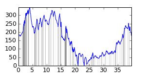
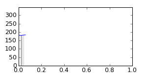
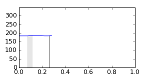
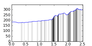
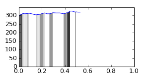
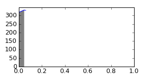
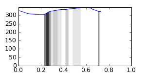
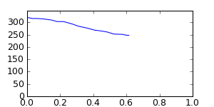
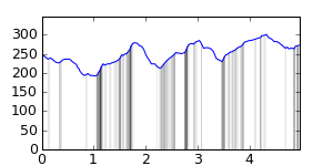
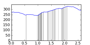
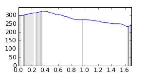
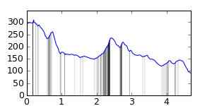
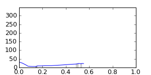
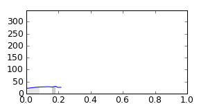
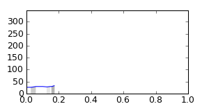
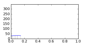
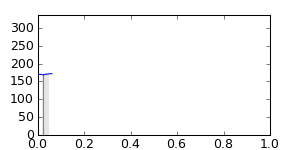
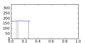
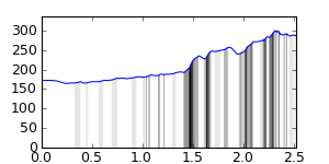
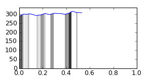
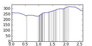
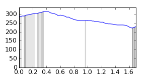
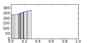
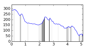
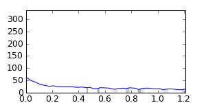
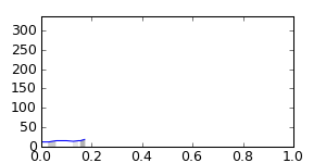
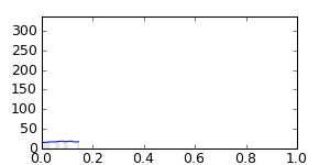
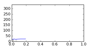
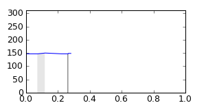
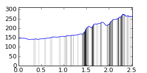
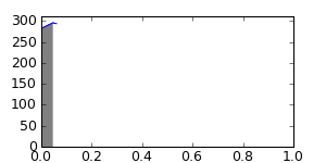
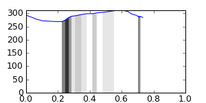
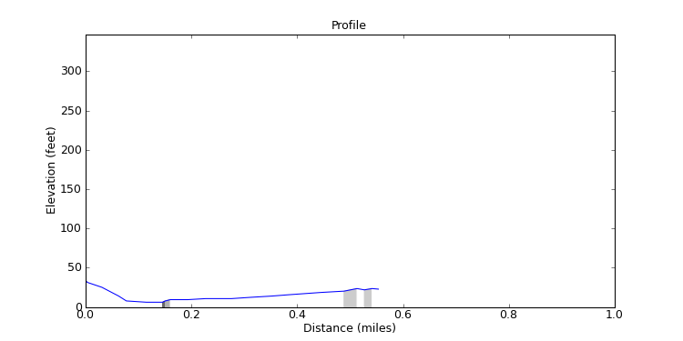
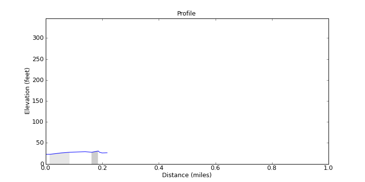
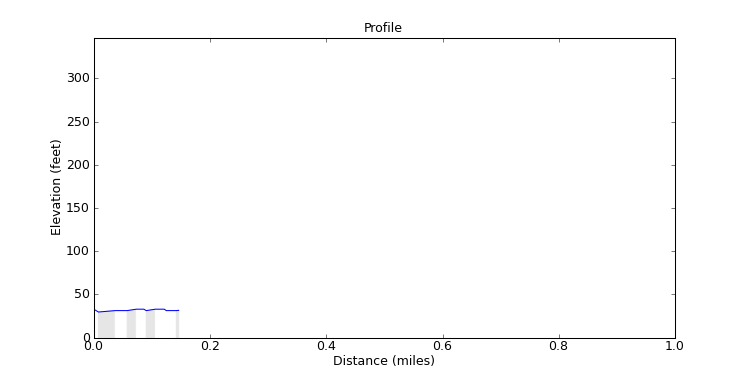
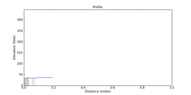
This is an analysis of the elevation data for the ride and for each of the segments of the ride.
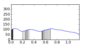
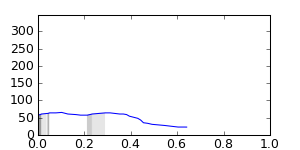
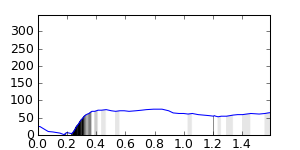
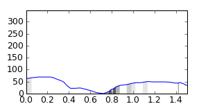
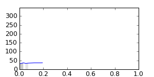
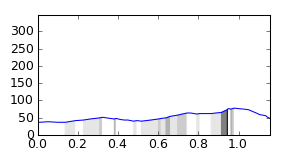
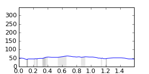
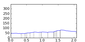
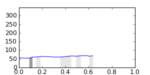
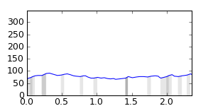
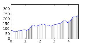
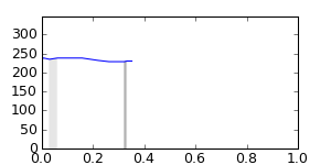
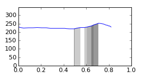
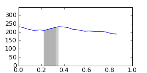
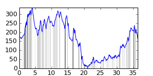
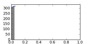
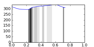
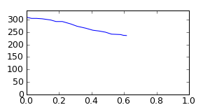
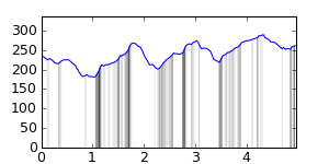
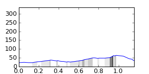
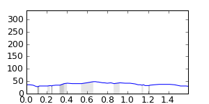
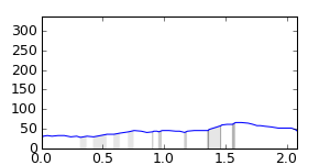
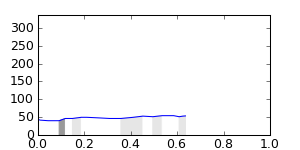
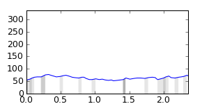
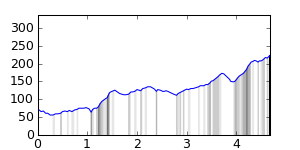
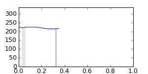
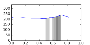
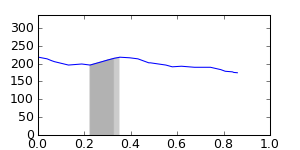
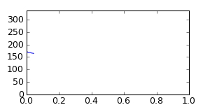
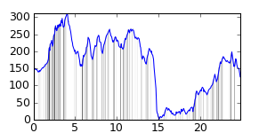
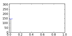
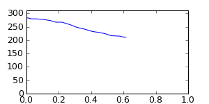
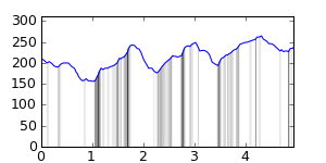
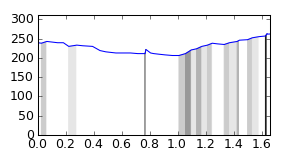
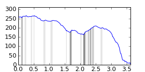
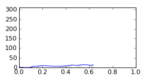
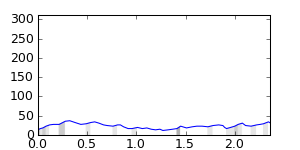
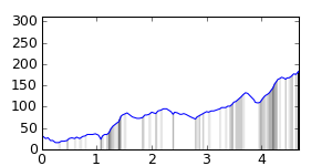
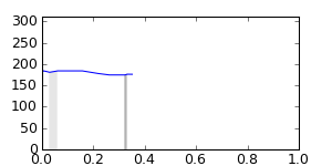
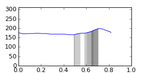
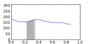
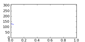
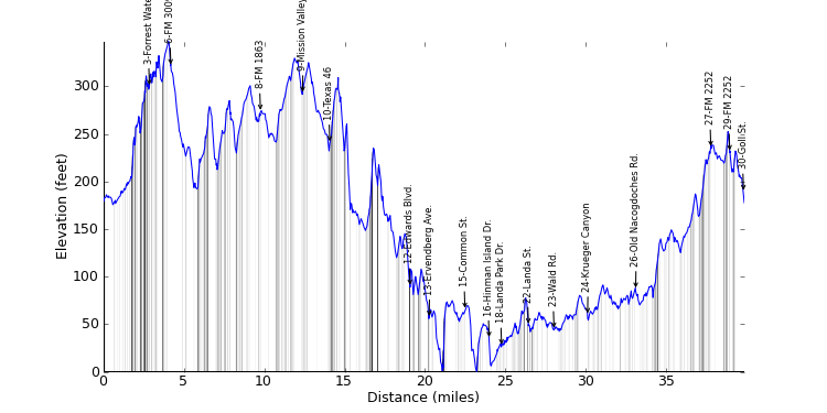
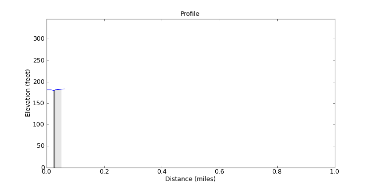
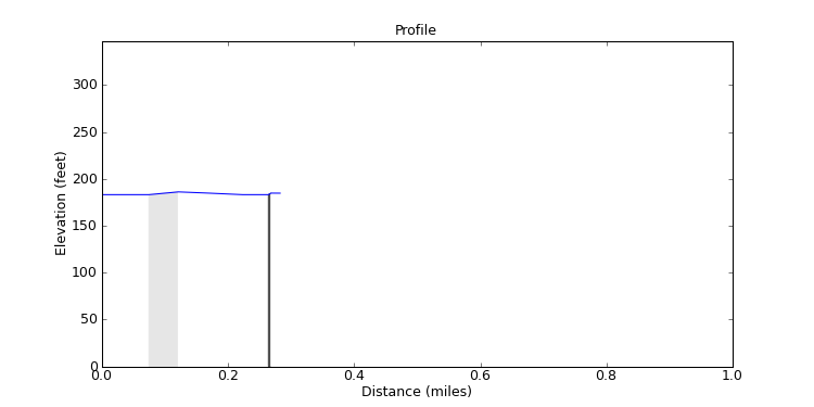
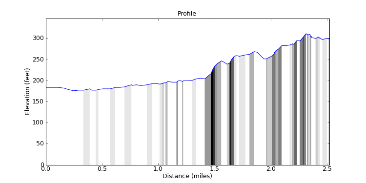
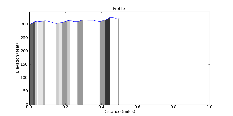
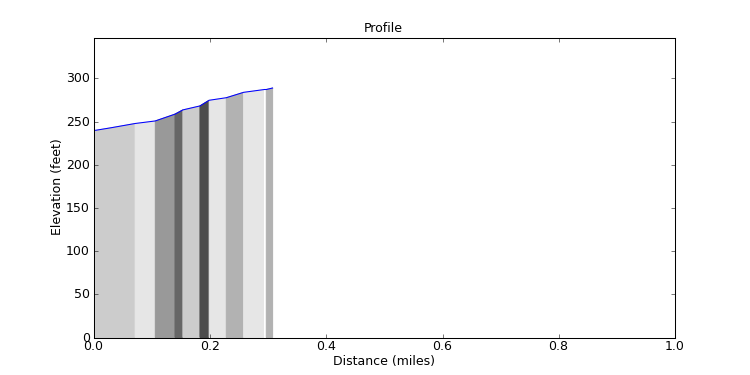
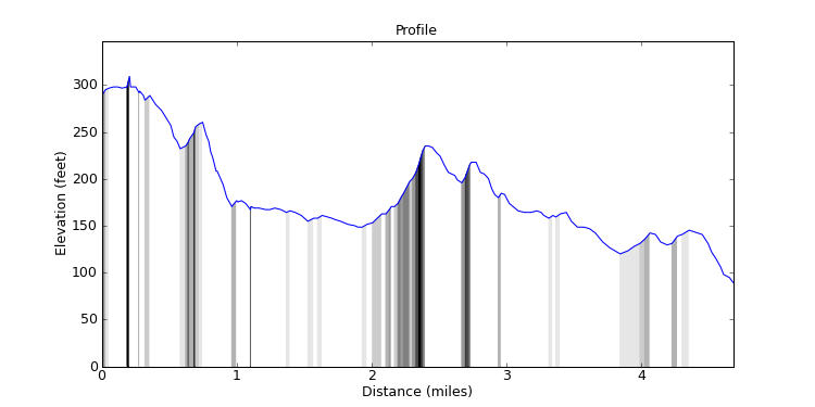
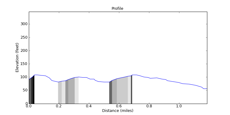
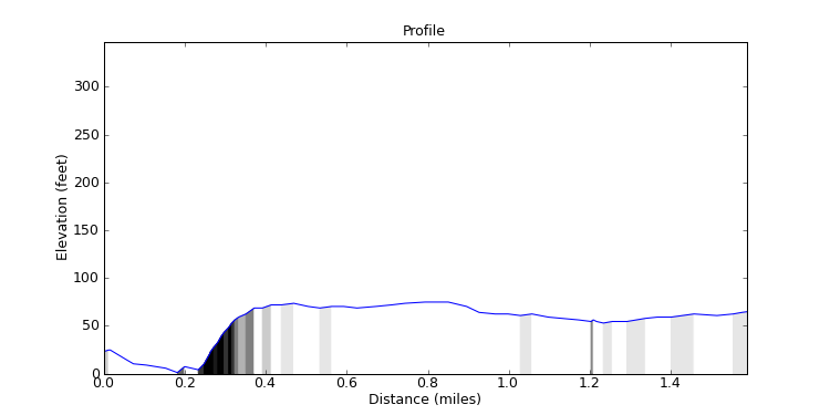
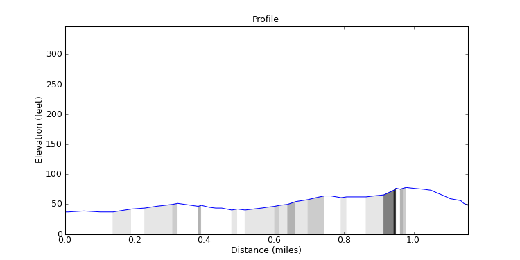
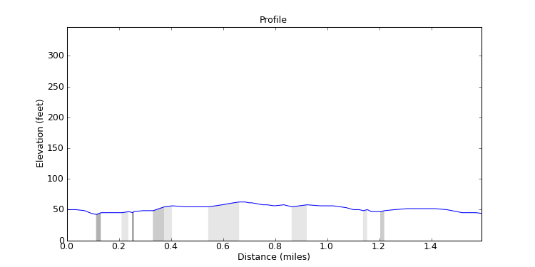
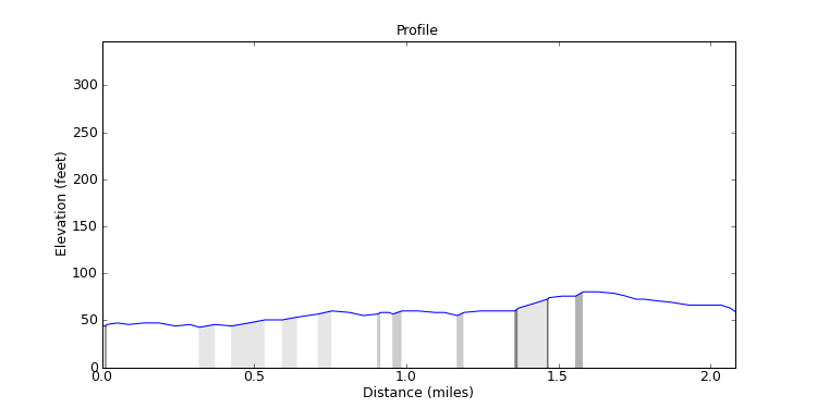
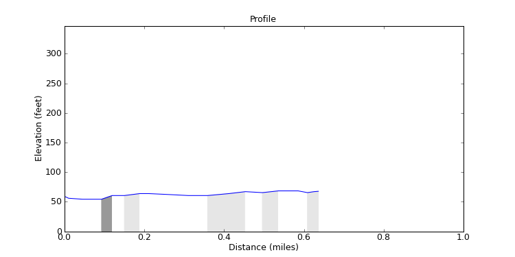
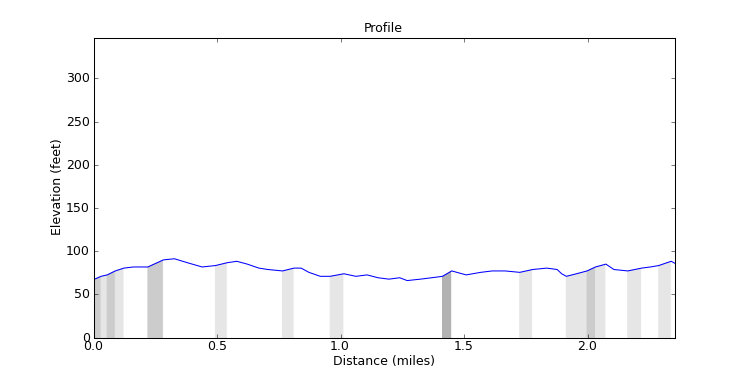
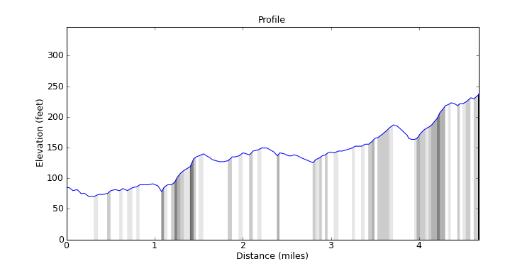
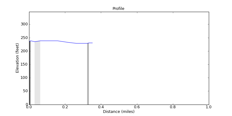
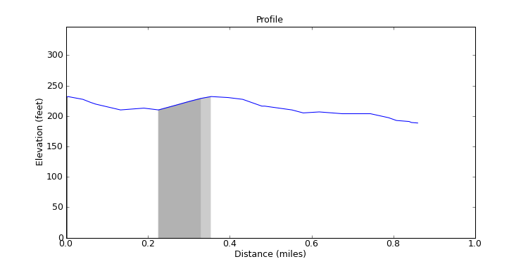
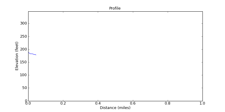
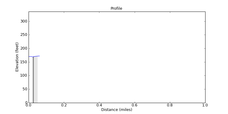
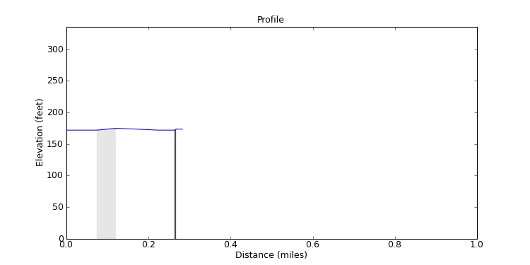
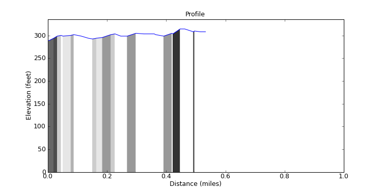
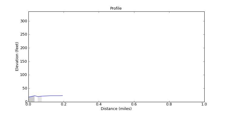
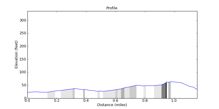
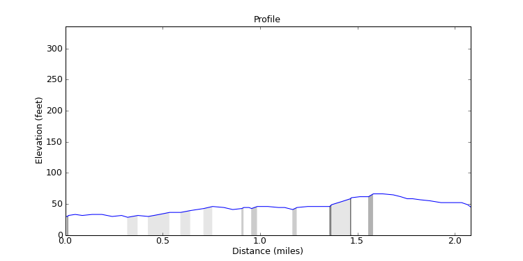
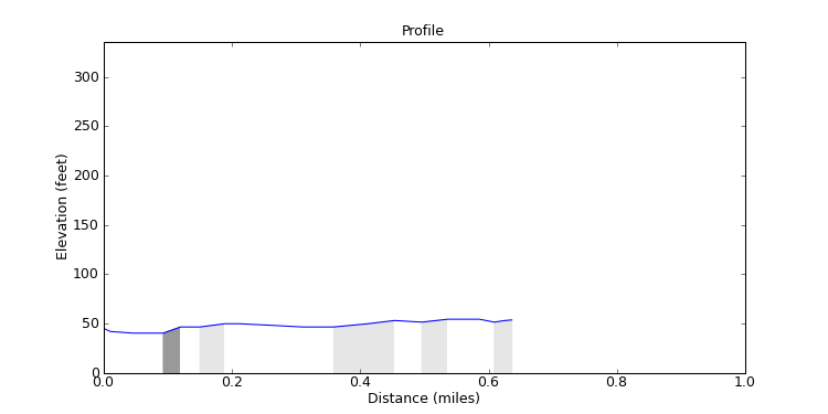
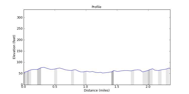
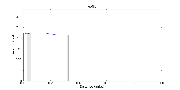
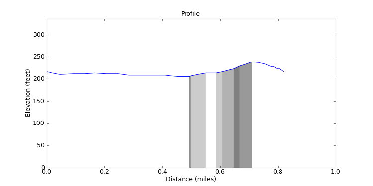
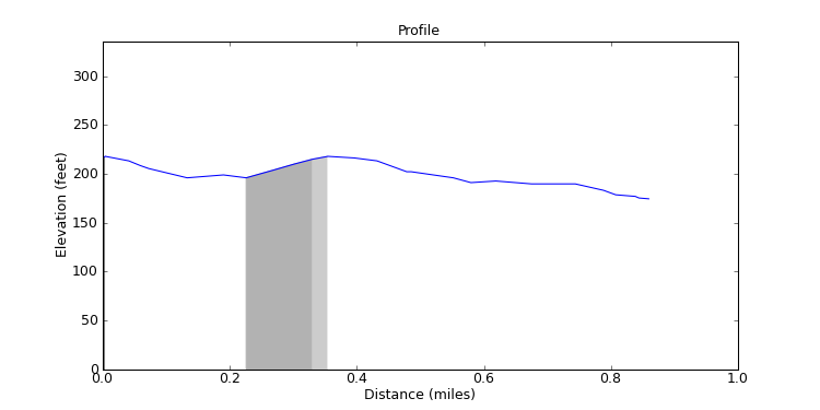
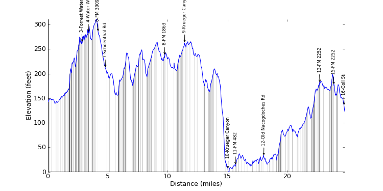
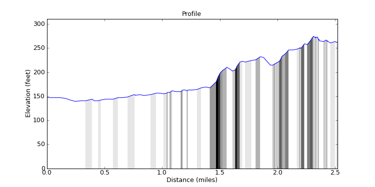
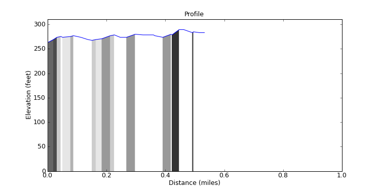
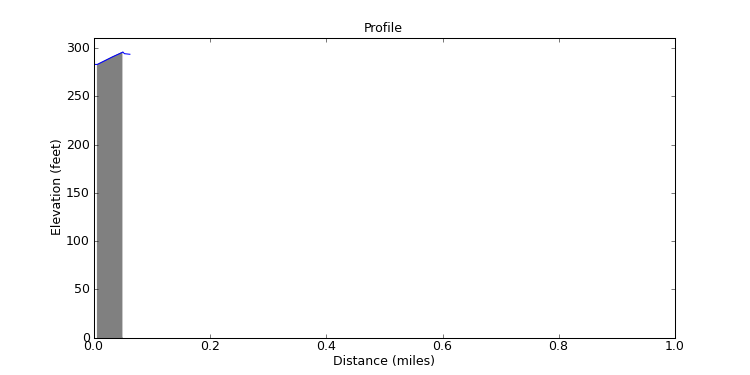
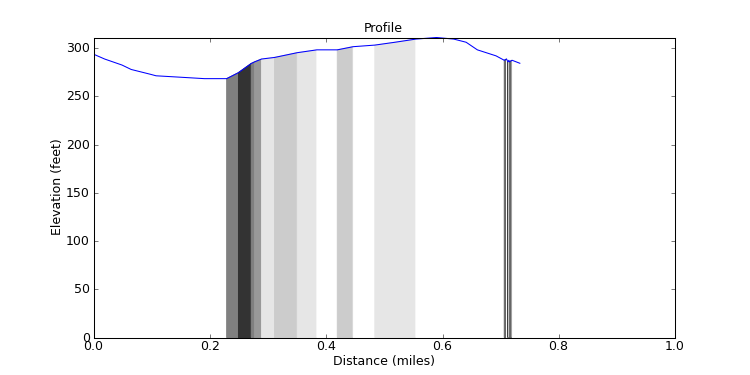
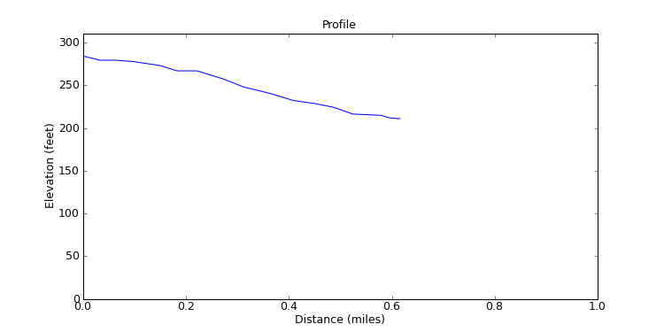
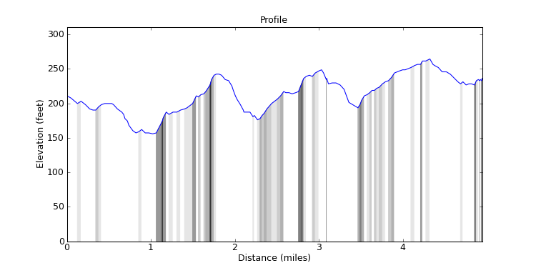
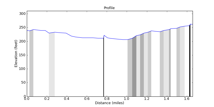
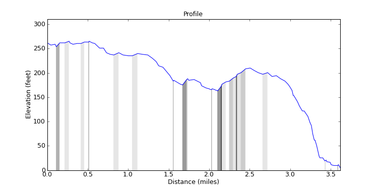
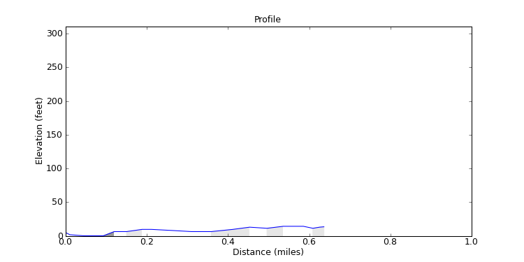
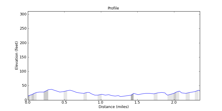
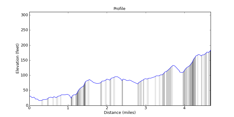
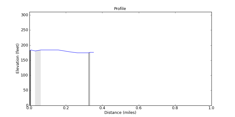
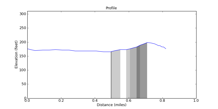
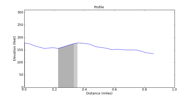
The graphs show the elevation profiles. They are shaded underneath to show how steep each part of the ride is, lighter for less steep all the way to black for very steep. I normalize the height so you see elevations from 0 to the tallest point on the ride. I don't put the true elevation above sea level because, for the San Antonio area, elevation above sea level isn't very interesting since we're never high enough to make a difference. Also, you can click on a graph to see a larger version of it. The larger graph will pop up in a separate window.
The ride and segment analyses show how much climbing and descending you'll do in the ride or segment and what the average grade is for each. The climb list tells you how steep and how long the worst climbs in the ride or segment are, and is ranked by steepness.